Around Bevan Road in Cumberland sits about 500 hectares of land that represent most of the available industrial land in the Comox Valley.
In light of this, the Village of Cumberland has been working to identify how this land could develop over the next couple of decades.
“It is 84 per cent of all the remaining industrial land in the Valley,” said Cumberland’s economic development officer, Kaelin Chambers.
By comparison, he said Courtenay and Comox each have under less than seven per cent.
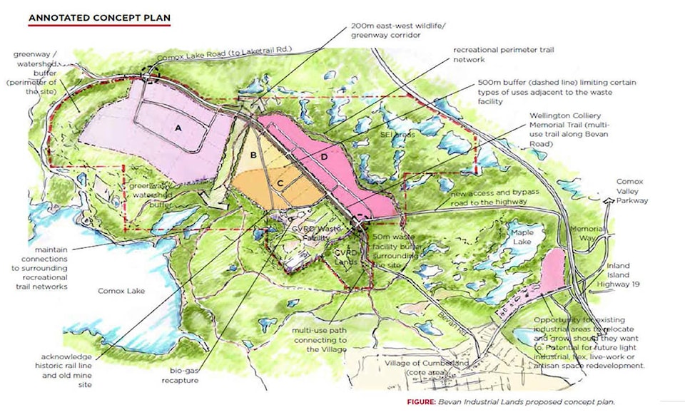
At a recent committee of the whole meeting, Chambers provided Cumberland’s council with the latest concept plan at how the future of industrial development in Cumberland – and the Valley – might take shape in the coming years. Currently, the land, near the region’s landfill site, is marked by a gravel road, but little else in terms of development.
At this point, it’s all a suggestion because the Village’s role here is really to facilitate discussion among the several stakeholders, which include a forest company, a yogurt manufacturer and the Comox Valley Regional District.
“We’re not the landowner, we’re not developers. We are facilitators in a sense in making sure these conversations happen,” Chambers said.
His report to council notes that the projected demand in the region for “employment land” is between 3oo and 430 acres, from 2011 through to 2045. The current plan takes into account development for the next 10 to 15 years. The demand is becoming more diverse, with opportunities identified for sectors such as waste management; recycling and green energy; construction and aggregate processing; food production and processing; and forestry.
The concept plan maps show a couple of large industrial areas with three sub-areas to the northwest of the site. Potential operations could include heavy industry, aggregate, silviculture, cannabis facilities, outdoor storage, or salvage and wrecking.
Separating this part from the southeast portion is a 200-metre greenway and wildlife corridor. On the other side is land that could a potential food processing hub, or other light industry, as well as other land for an eco-industrial campus. A map also marks additional road access points and a commuter bike path, along with a watershed protection area between the site and Comox Lake as well as future park or conservation areas to the east.
“When we talk about environmental attributes, of course, this is one of the big things that was very important to the stakeholders … being it’s located between the Morrison Creek headwaters and the Comox Valley watershed,” Chambers said.
RELATED STORY: Courtenay yogurt maker looks to site in neighbouring community
RELATED STORY: Cumberland expects draft plan for Bevan Road in 2020
There were conversations last fall after Tree Island Yogurt announced plans to move from its current location in the south Courtenay area to land at Bevan Road – a first phase of development at the site. The plan was also presented with the Comox Lake Watershed Advisory group and the Courtenay District Fish and Game Protective Association.
From stakeholder conversations in October, the plan started to take shape, though Chambers admitted the pandemic has slowed down the process.
At the end of the presentation, council passed a motion to refer the concept plan to the economic development steering committee for feedback. That meeting will take place in early September in order to provide input for council at a subsequent meeting next month.
mike.chouinard@comoxvalleyrecord.com
Like us on Facebook and follow us on Twitter.