Scott Stanfield
Record Staff
The recent multi-day storm that flooded parts of the Comox Valley has re-ignited arguments that claim deforestation is a major contributor to the problem.
Courtenay resident Rick James, for one, is saddened and frustrated when he considers the east coast of Vancouver Island. Once resembling Cathedral Grove, he says the area now contains less than one per cent of first growth timber.
“It goes back to the Esquimalt/Nanaimo land grant,” said James, a career tree planter. “We’re not looking at Crown land, we’re looking at private property. The southeast part of Vancouver Island, this is the primest habitat for growing Douglas fir anywhere on the planet, and we’ve pissed it all away.”
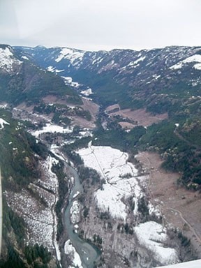
He blames forest companies for clear cutting in and around Mount Washington, the Tsolum headwaters and Comox Lake, among other areas, thereby causing flooding.
James says the low-lying valley has disappeared in the Cruikshank River, which is a major drain that runs into Comox Lake. Also noteworthy is the north side of Mount Washington that has been stripped bare.
“There’s nothing there to hold back the waters coming off those hills,” James said. “This is an environmental disaster. It’s not climate change, and it’s not BC Hydro’s fault.”
TimberWest’s chief forester Domenico Iannidinardo — who questions the evidence on which James bases his claims — says water management is a primary driver of the company’s forest planning and operating activities.
“There is a variety of independent science that is incorporated into our planning,” said Iannidinardo, who notes that natural flooding has historically occurred in the Puntledge River.
Science indicates forestry in this part of the world can be expected to have negligible influence on stream flows in large, multi-day storms. Iannidinardo also notes that rainfall intensities are trending higher than previous 50-year averages, and that climate variability correlates with ocean currents.
Though historical logging practices have no doubt impacted flooding, a local scientist at the David Suzuki Foundation suggests the entire watershed needs to be considered.
“My gut feeling is it’s (deforestation) probably a negligible factor,” senior research scientist Scott Wallace said. “A lot of the rain would have fallen on marginal or non-economic timber lands. There’s a huge amount of area that’s not logged, not even historically logged, and currently not in a state of forest succession that would contribute to a flooding.
“In this case I would say this is an extreme weather event that happens more frequently, so there’s probably the climate reality coming to bear. (But) It’s hard to prove these things.”
Wallace feels the true cause of local flooding is the “fact that we’ve diked off the floodplain and then built in it.”
Dyke Road, he notes, is true to the name — it’s a dike — which is preventing water from entering the field as it did in years past.
“That’s the floodplain. That’s the issue.”
Going forward, if the City of Courtenay hopes to control floods naturally, Wallace suggests natural ecosystem services need to be used to rebuild the floodplain.
“If we’re going to have more rain coming down and more flooding, then you need a place to put that water. In my mind, the best place for that is to let it go where it’s supposed to go naturally, which is in the floodplain, and that floodplain’s been diked off.”
reporter@comoxvalleyrecord.com