As flooding continues to impact various regions in the B.C. Mainland, the Comox Valley Regional District is keeping an eye on one of its own areas prone to rising water levels.
The CVRD’s electoral area services committee was presented with a flood mitigation and risk assessment report for the Oyster River and Saratoga Beach region at its May 14 meeting.
Prepared by Ebb Water Consulting, the report outlines the flood hazards for the two communities and how to support future planning for disaster risk reduction. The report stems from 2016, when the CVRD successfully applied for funding for a study from the National Disaster Mitigation Program (NDMP).
Oyster River has historically been one of the Comox Valley’s most vulnerable communities when it comes to flooding. According to the Ebb Water report, eight significant flooding events have occurred in the region since 1975.
“Several events in the last decade have caused renewed concern for flooding in several areas of the community,” reads the report.
A recent incident was in December 2014, when high water levels caused the Oyster River to flood and generated significant property damage.
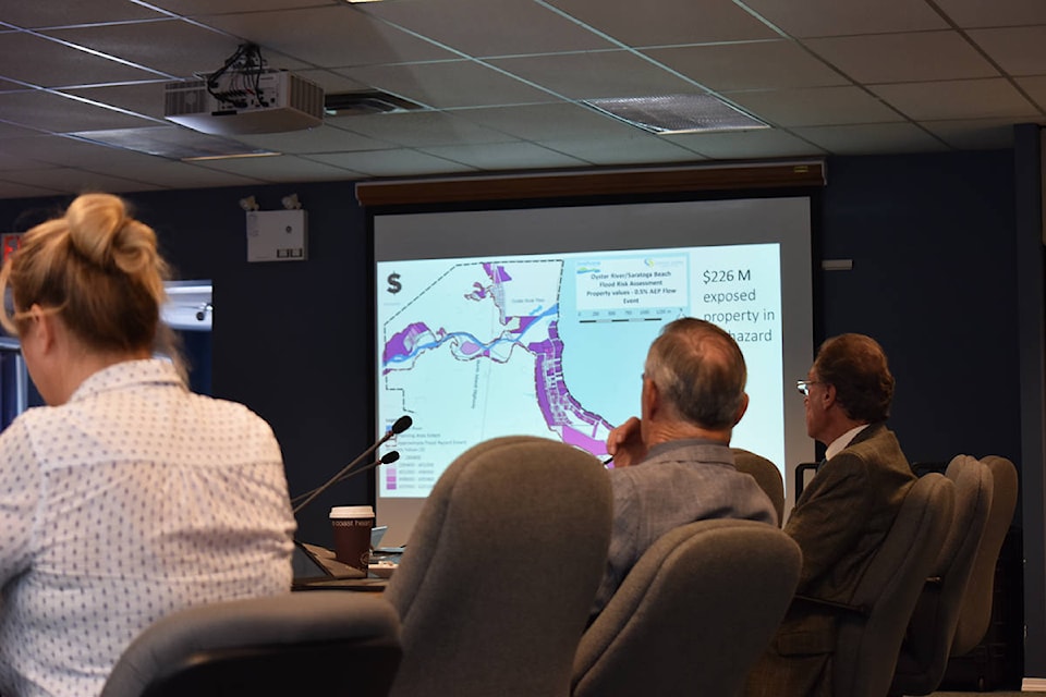
According to the report, a minimum of 550 people would be impacted by a flood in Oyster River or Saratoga Beach. The estimated value of exposed property of the floodplains is worth $226 million.
Ebb Water’s assessment concluded that “there is a significant flood risk in the region” and that risk reduction should be among the CVRD’s priorities.
“It is clear from the above analysis that affected people and economic damage risk is significant in both the present-day and in the future with climate change,” it reads.
The report recommended the CVRD pursue additional funding from the NDMP or the Union of B.C. Municipalities to develop a hydraulic flood mapping for Oyster River/Saratoga Beach at a cost of about $175,000. Such mapping would define the erosion areas most at-risk of flooding and be a necessary tool for future resilience planning in Oyster River
Committee members supported that report’s recommendation on Monday, meaning it will now go to the CVRD board of directors.
George Doerksen, the CVRD’s deputy emergency program co-ordinator, said updated flood mapping will allow the regional district to do a better job of pre-planning for potential disasters.
“Currently we have a flood evacuation guideline for the Oyster River area,” he said. “We have things like evacuation routes identified, reception centres, staging areas, things like that.
“[Flood mapping] will help us respond to emergencies better in the future.”