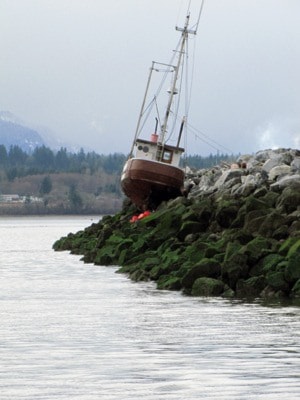
Although it felt like a hurricane that walloped the Comox Valley, meteorologists from Environment Canada said Monday's storm fell just shy of qualifying as one.Cindy Yu, a meteorologist for Environment Canada, said they recorded wind gusts of 106 km/h at the Comox weather station."When it comes to hurricane winds, it must be a sustained strength. Winds may have come close to that, but it has to be sustained," she explained. "Gusts are usually less than 20 seconds — maybe five or 10 seconds — and for a hurricane it has to be an average of several minutes."She noted for winds to be classified as a Category One hurricane, sustained wind must reach a minimum of 118 km/h. Monday's storm was classified as a tropical storm.Yu said since the weather agency began recording wind speeds at the Comox weather station in 1953, there have 27 incidents of wind reaching 106 km/h or higher, with the record set in March 1985, when wind reached 133 km/h.According to Ted Olynyk, BC Hydro community relations manager, 27,000 Comox Valley area customers lost power during the peak hours of the storm on Monday between 10 and 11 a.m."The whole east coast was hit pretty hard," said Olynyk. "But, certainly, it was the Courtenay/Campbell River area that was hit the hardest on the Island. It was "definitely the big one this year, and it was one of the bigger ones we've had in a while."About 4,700 Comox Valley area customers were still without power Tuesday morning. Olynyk said crews were brought here from the south and mid-island, and even Vancouver, to help with restorations."We're trying to put as much resources as we can in the area," he said Tuesday. "We had crews working last night and, of course, crews are working today — a lot of crews."While the majority of the Courtenay area was without power Monday morning, according to Jane Murphy, president and CEO of St. Joseph's General Hospital, the hospital did not lose power due to its backup generator.Olynyk said he couldn't comment on St. Joe's specifically, but noted that some hospitals have a number of feeds to draw power from, so that if one feed goes out another can be used. He added that areas around hospitals are typically very well maintained in terms of things like vegetation near power lines, because they are a priority.Schools in the Comox Valley and Campbell River were closed Monday. Huband and Hornby elementary schools remained closed Tuesday.Transportation was disrupted throughout the region.B.C. Ferries cancelled more than 90 sailings on 15 routes Monday, including four sailings on the Comox to Powell River run. Service resumed at 3:15 p.m. with the last two round-trips sailing from the Little River terminal.Sailings were also cancelled from Buckley Bay to Denman and from Denman to Hornby, though some terminals managed to squeeze in their initial round trips."It (cancelling sailings) does happen from time to time," said BC Ferries spokesperson Deborah Marshall, noting more than 130 sailings were cancelled during a January storm.Ferry service was back to normal Tuesday.A handful of flights were cancelled or delayed at the Comox Valley Airport.Christianne Wile, manager of marketing and public communications, said three early-morning flights from Pacific Coastal and Central Mountain Air were cancelled, and a direct flight to Cancun was delayed for one hour. "We did receive a lot of calls from passengers checking the status of their flights," she explained. "We encourage guests to keep up to date with their flights by phoning the individual airlines or checking the Comox Valley Airport website. We also ask guests to give themselves extra time to get to the airport (in extreme weather)."Wile added the decision to land at the airport is made by each individual airline.The storm wasn't strong enough to sink any boats in Comox Harbour, though one was left about three-quarters submerged in the bay after being bumped by a fish boat.Another sailboat was left high and dry at Jane Place, while a 42-footer broke free from its mooring and is resting on the rock breakwater at Comox Bay Marina. In addition, a 50-foot steel hull pleasure craft that was anchored in the middle of the bay is sitting high and dry on the beach underneath the hospital. "We recorded wind speeds down here of 61 knots," said Robert Clarke, wharfinger at the Comox Valley Harbour Authority. "That's a pretty good gust." He said upgrades to the floating breakwater were sufficient to protect vessels on the east side. "No damage to any of our docks or any boat in our facility," Clarke said.The City of Courtenay opened an emergency operations centre at City Hall until 3:15 p.m. on Monday, according to director of legislative services John Ward. The City used a generator to keep the centre fully operational, and it was a good test of the generator for an extended period of time, Ward added.Flooding along the Courtenay, Puntledge and Tsolum rivers was a concern due to high tides, but the expected flooding did not happen.Looking ahead to Wednesday, Environment Canada has issued a wind warning for the Comox Valley, as an upper low-pressure trough is developing over the area, added Yu."The low doesn't look as deep as we had (Monday), but the winds are predicted to develop over the Strait of Georgia, with winds at near warning levels," she said.Environment Canada is predicting southeast wind to develop early Wednesday morning between 60 to 80 km/h over East Vancouver Island, and between 80 to 100 km/h over northern Vancouver Island. Yu noted residents tend to forget the area is not out of storm season just yet, despite the calendar indicating spring is less than a week away. "As we slowly transition into warmer weather, we do tend to get more storms. The transition period is relatively windy and rainy," she added.